Going on a hike?

Check out these resources!

Trail Maps

2025 TMR Trails Map
Use this map to plan your hike with the most up-to-date campsites, historic sites, trails, and availability of drinkable water.

TMR Trails foldable map
These fantastic foldable pocket maps can be purchased and mailed for you and your Scouts to navigate your way to the adventure of a lifetime!
Visit the link above to purchase maps from the TMR Musuem.

Hiking Guide

Explore the many possible hikes available; from a short day hike to a 3-day expedition, this is the best information around for your trip to TMR!

Guide to Hiking at TMR

Trail Maps on your phone!

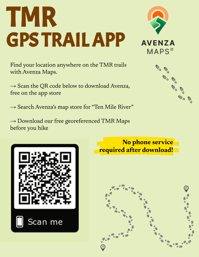
See your location via GPS anywhere on the TMR Trails, no service or wifi needed… and completely FREE!!!

Avenza App
Download the Avenza Maps app, available on both the Google Play Store as well as iPhone’s App Store.

After downloading the app, you will need to download the TMR Trails map while you still have wifi or service. You can scan the QR code on the right, or head here:
Avenza Map Store: TMR Scout Camps Trails Map

FREE trail maps!

Copies of the new T.M.R. Trails map can now be obtained, free of charge, from the G.N.Y.C. Awards Center. Just visit the Awards Center at the G.N.Y.C. office (Mondays & Fridays, 9:00 am-5:00 pm) and ask Kristen for a map. The Awards Center has a variety of merit badges, rank badges, Cub Scout belt loops, neckerchiefs, CSPs, a few backpacks and a compass or two.
While you are there (and if the Awards Center is closed), you can always plan out your next T.M.R. hiking adventure using the T.M.R. Trails map hanging on the wall outside the Awards Center.
The free Trail Maps can also be found at TMR this summer. Ask your camp director or the museum for a map.

Trail Conditions

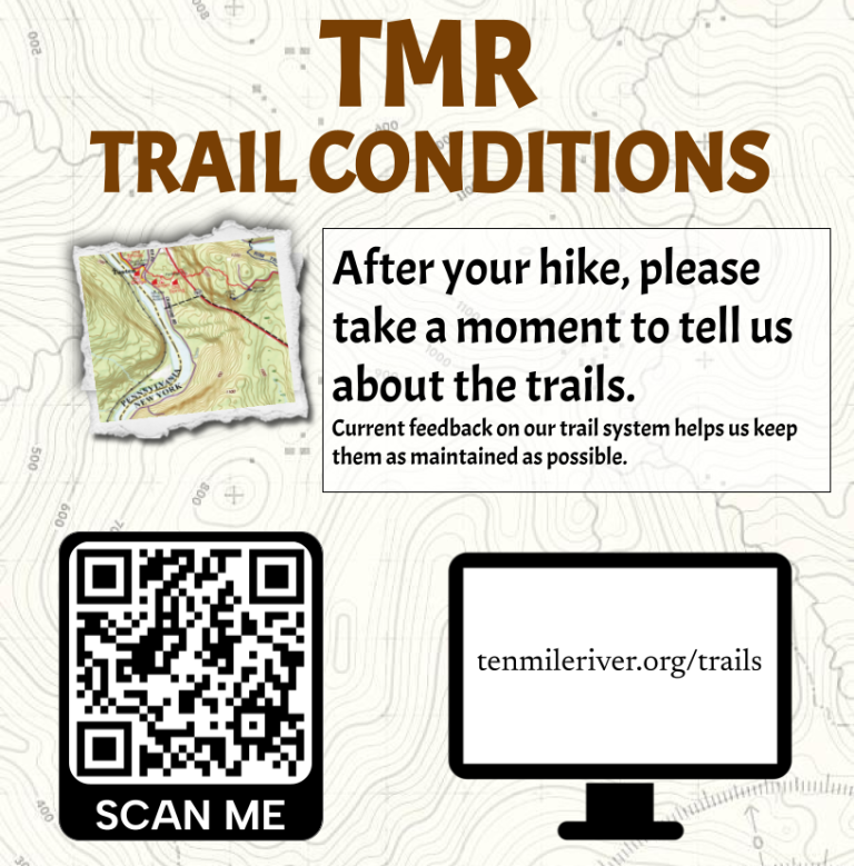
We want to deliver the best experience possible. To help us maintain the trails, please consider filling out this short survey after your hike:
tenmileriver.org/trails/

Planning on doing trail work? Help us even more by using Avenza to note locations of downed trees, etc:
tenmileriver.org/avenza/

Historical Trails Medal information:

Download the PDF from the files section below.

Special thanks to Sean Johnson who created these Hiking Guides and to David Malatzky and the TMR Museum.

Attachments

  • pdf TMR Trails Map 2025
    File size: 4 MB
  • pdf TMR Historical Trails Brochure
    File size: 3 MB
  • pdf Guide to Hiking at TMR2020
    File size: 5 MB
  • pdf Ten Mile River Historical Trails Map Book
    Ten Mile River Historical Trails Map Book - This 24-page book includes a 14-page TMR Trail Map (in sections) with historic sites identified and 8-pages of historic site history.
    File size: 8 MB
  • pdf January 2019 TREX Trek Presentation
    File size: 6 MB
  • pdf Hike Guide a visit to Trout Pond - fairly easy
    This hike is a variation of the “Crystal Lake Loop” hike, in that it includes a visit to Trout Pond. This is a great option for adult leaders wishing to teach and/or supervise the use of map and compass for aspiring 2nd Class scouts, as it will meet that rank’s requirement 3(b) -the five mile hike.
    File size: 5 MB
  • pdf Hike Guide Black Ash Swamp loop - easy
    This is a great introductory day hike at Ten Mile River. The hike begins on the main TMR Trail (marked with red markers) at the Ten Mile River Scout Museum in Headquarters and travels around the east side of Turnpike Pond.
    File size: 3 MB
  • pdf Hike Guide Crystal Lake Loop - fairly easy
    This is a popular hike not only because of its proximity to Ten Mile River’s largest summer camp at Camp Keowa but also because of its spectacular scenery.
    File size: 3 MB
  • pdf Hike Guide Delaware River
    It is a spectacular 6.4 mile hike starting near Ten Mile River Access, and follows Tusten Road and the Conklin Lookout Trail to the T.M.R. boundary and back again. Lots of great views of the Delaware River!
    File size: 6 MB
  • pdf Hike Guide a hike to Indian Cliffs - fairly easy
    The hike to Indian Cliffs from the Camp Kunatah gate is perhaps one of the most (if not the most) popular segments of the entire TMR Trail. Rather than the usual “out and back” route, I have added an additional portion that will walk the length of Rock Lake, creating a loop.
    File size: 3 MB
  • pdf Hike Guide Renowip Trail
    The Renowip loop hike starts and ends at the Barta House and presumably would be of interest to Units renting that facility and perhaps to Units attending summer camp at Camp Aquehonga.
    File size: 8 MB
  • pdf TMR Trails Map Book version 1
    Ten Mile River Historical Trails Map Book - This 24-page book includes a 14-page TMR Trail Map (in sections) with historic sites identified and 8-pages of historic site history.
    File size: 10 MB
  • pdf TMR Trails Map Book version 2
    Ten Mile River Historical Trails Map Book - This 24-page book includes a 14-page TMR Trail Map (in sections) with historic sites identified and 8-pages of historic site history.
    File size: 13 MB
  • pdf TMR recommended hike routes map book
    These are recommended 10-mile, 14-mile and 30-mile hike routes that will satisfy the hiking requirement for the Ten Mile River Historical Trails award. Both documents are used together.
    File size: 3 MB
  • pdf turn-by-turn hike instructions
    TURN-BY-TURN Hike Instructions for the Recommended Histroical Trails Hike Routes Map Book. Please also download the Recommended Histroical Trails Hike Routes Map Book.pdf
    File size: 369 KB
  • pdf Upper Delaware region and TMR History
    The History of the Upper Delaware Delaware Region and the Ten Mile River Scout Camps, 36 pgs. Includes the history of all historic sites in the Ten Mile River Historical Trails Map Book
    File size: 2 MB
  • pdf Weekend Unit Roster
    File size: 241 KB